| . 1 . 2 . >> |
| Author |
Message |
paulz
Member
|
# Posted: 13 Nov 2023 11:01am - Edited by: paulz
Reply
Satellite and street view.
Let’s see yours
|
|
Steve_S
Member
|
# Posted: 13 Nov 2023 12:05pm
Reply
Hahaha I just looked for mine. Nope still shows as uncleared forest. it's only been 7 years or so...
|
|
FishHog
Member
|
# Posted: 13 Nov 2023 01:10pm
Reply
I don't think i'm ever going to have a street view of my place. At least not in my lifetime
|
|
paulz
Member
|
# Posted: 13 Nov 2023 01:16pm
Reply
Quoting: Steve_S Hahaha I just looked for mine. Nope still shows as uncleared forest.
Same here.
|
|
Grizzlyman
Member
|
# Posted: 13 Nov 2023 01:20pm - Edited by: Grizzlyman
Reply
Mine is on Apple Maps but not google maps … its from 2021 still… keep waiting for an update. It’s funny because I know exactly when they took it. It was taken within a 2 week span between having the roof done, but NOT having the screened in porch done… so it’s just a platform where the porch is now.
|
|
ICC
Member
|
# Posted: 13 Nov 2023 01:37pm - Edited by: ICC
Reply
No street view, the closest street view is the highway 6 miles away. (before wildfire)
-izzy
|
|
Nate R
Member
|
# Posted: 13 Nov 2023 01:59pm
Reply
Google maps hasn't updated aerial veiws around me for I think 9 years now...
But Bing maps is within 2 years!
|
|
Nate R
Member
|
# Posted: 13 Nov 2023 02:02pm
Reply
Forgot to add mine.
I know when this was from...my cabin is roofed, but the camper (in yellow) still there before I got rid of it. In red is my shed roof visible. 
|
|
|
paulz
Member
|
# Posted: 13 Nov 2023 02:03pm
Reply
I could swear you could see my roof at some date. The map on my Iphone looks the same. Is Bing different?
|
|
gcrank1
Member
|
# Posted: 13 Nov 2023 02:29pm
Reply
I have a Google Maps pic that has to be 2020, another 'window of time' between spring and fall in our clean up of the site.
Place is a mess, looks like a small business plane crash debris field. We cleaned it ALL up by this time in 2020, sure would like to see a current pic!
|
|
ICC
Member
|
# Posted: 13 Nov 2023 04:59pm
Reply
If you use Google Earth rather than Google Maps, there are extra available features. There are mobile versions as well as a web browser, and a desktop version, Windows, Mac and Linux. Version Info
I like the desktop version.
Anyhow there is a time slider in Google Earth Pro. see image for screenshot.
-izzy
|
|
Nobadays
Member
|
# Posted: 13 Nov 2023 05:40pm - Edited by: Nobadays
Reply
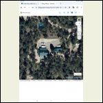
Google maps, really old picture.
Edit.... Wow Bing maps is within a year or two!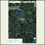
Screenshot_20231113.jpg
| 
Screenshot_20231114.jpg
|  |  |
|
|
spencerin
Member
|
# Posted: 13 Nov 2023 06:50pm
Reply
I had no idea Bing Maps existed. Google Maps hasn't updated my place in 3 years; Bing seems to be within the past year.
|
|
Fanman
Member
|
# Posted: 13 Nov 2023 06:54pm - Edited by: Fanman
Reply
Our cabin is in the middle of the picture. The middle of the three on the right is our old cabin, we didn't have to move far, but it's a bigger cabin and now our patio is on the cliff edge with a nice view of the stream down in the valley.
Street view will never see these cabins, but did capture my wife driving our camper along the road across the lake, not once but twice. There's no vehicular access to the cabin; those aren't roads you can see in the pictures, but gravel footpaths that wind through the community.
|
|
toyota_mdt_tech
Member
|
# Posted: 13 Nov 2023 08:30pm
Reply
The ranch, you can see some of the campsites, well enclosure, cabin, shelter, shed...
|
|
paulz
Member
|
# Posted: 14 Nov 2023 10:48am
Reply
My 8 acre lot fronts a paved road. Here is my gate, the cabin is another 1,000 drive up the hill. Can’t hear traffic, unless outside and a loud truck goes by. At night, on the deck, you can see headlights go by if you peer through the trees.
|
|
drb777
Member
|
# Posted: 17 Nov 2023 12:28pm
Reply
As you may suspect, county accessors also use online satellite maps to conduct assessments and reasons to inspect your property. In my case, a contractor hired by the county showed up one day, unannounced for an inspection. And told me he spotted activity on my acreage from online mapping. He had one of those magnetic signs on his super-fancy truck as his authority and right to check out anything as he pleased. I'll be keeping the gate locked at all times in the future.
|
|
ICC
Member
|
# Posted: 17 Nov 2023 02:56pm - Edited by: ICC
Reply
Quoting: drb777 I'll be keeping the gate locked at all times in the future.
Some counties will not enter land with a locked gate or No Trespassing signs, if the county assessor bylaws prohibit access without the owner being present. Many counties have their bylaws written to permit access to properties with locked gates, No Trespassing signs or nobody answering the door. The assessor can ask questions (how many bedrooms, etc) but you don't have to reply. Assessors will usually just measure the outside. If they can't access the property they will estimate; maybe they will err on the high side? If one owns property there are taxes.
-izzy
|
|
Irrigation Guy
Member
|
# Posted: 17 Nov 2023 06:38pm
Reply
Here is mine from Apple Maps, google hasn’t updated my area in at least 5 years.
|
|
Alaskajohn
Member
|
# Posted: 19 Nov 2023 07:39pm
Reply
Thankfully street view hasn’t made its way out to my neck of the woods.
|
|
Jackson
Member
|
# Posted: 20 Dec 2023 08:03pm
Reply
No street view, just space. Amazing how small 20 acres look from a computer screen...
|
|
gcrank1
Member
|
# Posted: 20 Dec 2023 09:40pm
Reply
Hey, your cabin looks just like mine!
|
|
paulz
Member
|
# Posted: 21 Dec 2023 11:22am
Reply
Wow nice! I have tried a hundred times, just tree tops. I do get a blue dot, guess that’s where it picks up my cell phone.
|
|
paulz
Member
|
# Posted: 14 Mar 2024 01:12pm - Edited by: paulz
Reply
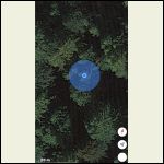
When on Apple Maps how close is the blue dot that shows your phone? An image appears that looks nothing like my cabin, and if I walk around with the phone it seems to circle the image.
No idea how old the image is, what it is or what size it would be. Google maps, Mapquest etc. don’t show it, just trees. There was nothing here before and nothing else on my property that resembles it. Can’t tell if it’s a roof, floor, side of a structure..
|
|
paulz
Member
|
# Posted: 20 Mar 2024 03:25pm
Reply
Quoting: Irrigation Guy Here is mine from Apple Maps, google hasn’t updated my area in at least 5 years.
Take another look please. I was looking at mine today and it looks like it may have changed. Hard to tell since it's all just tree tops. I looked online, apparently they provide no date of images.
|
|
paulz
Member
|
# Posted: 14 Jun 2024 11:14pm
Reply
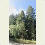
I finally found my cabin on Street Maps! I was beginning to wonder if I really existed. Here’s a closeup, and the whole shot. It’s from the next gate down the street (and to the right of this telephone pole if you zoom in, up high).
I’ve been spending the evenings while the wife watches the tube, searching street maps up and down the road in front of my property, nothing but trees. Same with the overhead shots.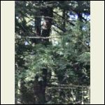
IMG_2798.jpeg
| 
IMG_2802.jpeg
| 
IMG_2803.jpeg
|  |
|
|
ICC
Member
|
# Posted: 15 Jun 2024 12:09am
Reply
Quoting: paulz I looked online, apparently they provide no date of images
Do a search for Google Earth for desktop. I know there are versions for Linux and Windows, probably also Mac. It uses the same map data as what you see in s browser ot the smartphone app. However, the imagery date is given, AND there is a date slider to allow going back and forth for years.
|
|
paulz
Member
|
# Posted: 15 Jun 2024 12:12pm
Reply
The Google Earth on my IPhone, where those pictures came from, also has that date slider, but the past images are blurry. At my city house, which I will be at next Monday, I believe they are sharper. That is a desktop with Windows, maybe that is the Pro version and the iPhone is not.
On the Apple Maps street view I can’t find the cabin at all. But I can see, by looking at my gate image, the junk lying around is very old. No dates seem to be available. I built the cabin over 10 years ago, maybe the Appple images are even older.
|
|
paulz
Member
|
# Posted: 17 Jun 2024 07:26pm
Reply
Learned a little more about Street View on both Google and Apple (Satellite View is worthless for me, just tree tops). I’ve been moving the cursor up and down the street looking for the cabin, and kept noticing a big blurry spot at one area. Figured maybe a rain drop on the camera? But no, a little investigating tells me they do this to hide images and protect from thievery and such. If you look at cars you will see the license plates are blurred over. The blurry spot on my images is right where the cabin would be. There must be some automatic sensor that catches this stuff before it goes online. Also some way to sign on and eliminate the particular block that I don’t understand. Cops probably have it..
|
|
ICC
Member
|
# Posted: 17 Jun 2024 08:49pm
Reply
Quoting: paulz The blurry spot on my images is right where the cabin would be. There must be some automatic sensor that catches this stuff before it goes online. Also some way to sign on and eliminate the particular block that I don’t understand.
Google can decide if they want to blur anything on street view. They have blurred out nudity in some cases. Mostly they do not blur out ordinary addresses, unless they receive a request. Yes, anyone can request their home be blurred if the Google-owned image contains a face or other identifying info or anything that violates the Google-contributed Street View privacy policies.
I have no idea how or if you can request an image block to be removed. A search may come up with an answer.
I haven't run across many blocked street view images in a while, other than for a face here and there. It's been a very long time since I saw an entire home street view blurred like that and I use Google Maps a lot when going to places I may have never been.
My home is not on street view as Google never sent their car up my county road.
|
|
| . 1 . 2 . >> |

